Why Measure Water Levels?
Uses for water level data range from hydrographic purposes for making nautical charts to absolute global sea level monitoring for better understanding the circulation of the ocean and its role in world climate. National Ocean Service's modern water level measurement system allows for a variety of real-time, near real-time, and long-term applications. Real-time applications include hydrography, nautical charting, maritime navigation, and tsunami warnings. Near real-time applications include circulation surveys as well as hydrography and storm surge warnings. Long-term applications include marine boundary determinations, tide predictions, monitoring long-term sea level trends, coastal construction, oceanographic research, climate research and absolute sea level monitoring. In our discussion here we will concentrate on these three types of applications.
Real-Time Applications
Real-time in our context means that data is transmitted with a delay of no more than a few minutes. A real-time system in its most basic form consists of an instrument in the field, a telemetry system to transmit the data within a short period of time, and a system at another location to receive the data. Rapid data telemetry can be achieved in three complimentary ways. First and simplest is to retrieve data from a selected water level gauge via a telephone connection. Data for a selected length of time, up to and including the most recent water level measurement taken 6 minutes ago, can be downloaded to a computer. The second is to retrieve data via NOAA's suite of Geostationary Operational Environmental Satellites (GOES). When certain extreme values or patterns of water level are detected by the water level gauge it automatically begins to transmit to the satellite. The satellite then retransmits the data to NOAA's earth station. The third way uses a line-of-sight radio transmission link receivable by nearby users. Tsunami warning, maritime navigation and some hydrographic applications require make use of these real-time data transmission methods. These methods are pictorially represented in the figure below.
-
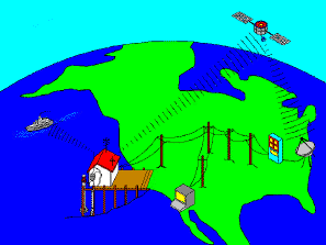
Real-time transmission methods
Tsunami waves, once generated by an undersea earthquake or other disturbance of the land, travel very rapidly. As they cross the deepest parts of the ocean they can attain speeds of 450 or more miles per hour! Considering that civil defense agencies working to inform and evacuate endangered coastal populations may require as much as six hours to complete their work, it is obvious that an early warning is lifesaving. Thus the need for rapid detection of the water level changes created by the tsunami waves. Once the water level gauge detects the onset of a tsunami wave the gauge places itself into a rapid data collection mode and begins transmitting this data to a NOAA satellite.
For maritime navigation in our harbors and coastal waterways real-time water level information contributes to the safety of life and property. In order to pass safely over the more shallow areas within a harbor or shipping channel the ship's captain must know the total water depth beneath the keel of the ship. The nautical chart will show the depth of water relative to a standard datum level (in the U.S. this is Mean Lower Low Water). But, what is the level of the tide. Is it high tide, low tide or somewhere in-between? And, what additional effects are present from higher or lower than normal river runoff or the wind moving water into or out of the bay. Real-time water level data from a nearby gauge give those answers for the consequences of running aground range from unpleasant to unthinkable.
Near Real-Time Applications
Near real-time in our context means that data is transmitted with a delay of no more than a few hours. A near real-time system consists of the same instrumentation, telemetry and data retrieval components as the real-time system. The main difference between the two is the speed with which the data are disseminated to users. For near real-time applications there are two dissemination methods. The first, by direct access to the water level gauge, allows acquisition of the last few hours (up to a day) of data. The second method is to connect directly to the system's database at NOAA's National Ocean Service headquarters. Since quality control of the data is limited for real-time and near real-time applications, only commensurately limited use of the data is appropriate.
Storm surge warning requires that data be available in near real-time. NOAA's National Weather Service Forecast Offices around the country employ the method of directly accessing a selected water level gauge and acquiring the last few hours of data. With it they can detect the onset of and warn against the dangerously high coastal waters associated with storm surge.
Hydrographic survey applications presently require three pieces of water level information most of which are satisfied by near real-time dissemination. These are: 1) a plan to demarcate the survey area into zones based upon tidal characteristics, 2) predicted tides for the survey area, and 3) water level data collected during the survey . As the hydrographic survey ship moves across the water taking depth soundings it must have knowledge of the present water level relative to some fixed vertical reference. This is used to adjust the soundings to a standard datum, like MLLW, upon which the nautical chart will be based.
Long-Term Applications
Water level monitoring over long periods of time are particularly helpful in understanding the circulation of the ocean and its role in world climate. The measurement of sea level stands out as one of the simplest and most effective methods for establishing long-term global databases of ocean observations. Recent scientific results indicate that sea level measurements: 1) have potential for supporting predictions of the onset of El Niño, 2) offer independent checks of global warming effects attributable to both natural variability and main-induced influences, such as enhanced greenhouse warming; 3) provide empirical estimates of heat transport by major ocean currents; 4) are essential to the success of satellite altimetry missions.
The National Ocean Service has been monitoring sea level variations for many years. For some locations, sea level records exist for more than one hundred years. The longest continuous sea level records exists for the Presidio, San Francisco, California. Records there go back to June 30, 1854. Recently, the long term sea level variations have become the subject of scientific interest related to the sea level rise associated with climatic changes.