Marsh Restoration
Coastal areas have intrinsic economic, cultural, and aesthetic value. Specifically, wetlands play a crucial role in the productivity of coastal waters, biogeochemical cycling, and geomorphological stability. They act as nurseries for fish and crustaceans and feeding grounds for birds; they store pollutants and nutrients; and they serve as buffer zones against floods and wave action.
Nevertheless, these fragile ecosystems have endured centuries of degradation and destruction. The United States has lost more than half of its wetlands since the late 18th century. An average of 60,000 acres of wetlands were lost each year between 1986 and 1997. Coastal wetland loss is caused by both human impacts (such as population growth and coastal development) as well as by natural phenomena (such as sea-level changes and erosion from coastal storms).
With habitat destruction and the natural systems that estuaries support failing, coastal habitat restoration is becoming a national priority. Thus, it is essential for restoration projects to be properly designed and engineered, and subsequently to be monitored. Because wetland vegetation is sensitive to how long and how often it is inundated (flooded), it is important for scientists and managers to understand the hydrodynamics of individual estuarine systems. This critical need for accurate water-level information and vertical datums to successfully restore and sustain healthy wetland ecosystems helped shape CO-OPS's COASTAL Program, which grew out of the former Marsh Restoration Program.
Three categories of water-level analyses are conducted for each marsh restoration project under the COASTAL Program: (1) local tidal datums are computed; (2) long-term sea-level change is assessed; and (3)the frequency and duration of inundation are analyzed.
First, tidal datum elevations are determined relative to present and future marsh surfaces by establishing a water-level station (typically for one year to capture seasonal effects) with local benchmarks. The figure to the right shows a generic marsh restoration study site. The tidal datums are then referenced to specific 19-year National Tidal Datum Epochs (NTDEs). The most recent NTDE of 1983-2001 was implemented in April 2003 to reflect the latest variations in Mean Sea Level (MSL) along the nation's coasts. The tidal datums are then further linked to a geodetic benchmark network using Global Positioning System (GPS) and/or leveling techniques, thus referencing them to geodetic datums, such as the North American Vertical Datum of 1988 (NAVD88). Then kinematic GPS (KGPS) surveys of marsh topography are used to generate digital elevation models (DEMs), which display visual representations of various datum elevation relationships. DEMs of tidal and geodetic datum relationships (specifically, Mean High Water and NAVD88) are beneficial in the planning and construction phases of marsh restoration efforts because they provide baseline information.
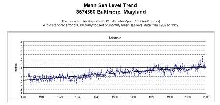
Secondly, long-term sea-level changes, trends and variations are assessed and analyzed to ensure that any rise in sea-level is appropriately considered during the extended planning phases. By conducting simultaneous comparisons of the high waters between the short-term station at the marsh and the nearby long-term control station, the same long-term sea-level trends can be expected at the marsh. Seasonal effects are determined and extrapolated in a similar manner. Finally, analyses on the frequency and duration of inundation (high water) are performed. This information is then used to determine where to plant restorative vegetative species.
-
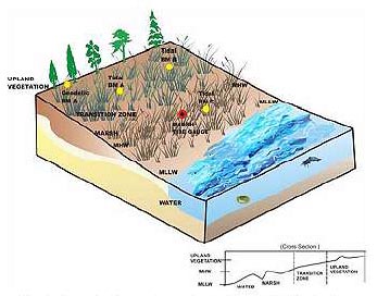
Fig.1. Schematic of a generic marsh restoration site. It includes a tide station(typically a one-year tide station), local tidal benchmarks, geodetic benchmarks, and delineates vegetation elevation zones, and tidal datum elevations.