National Current Observation Program (NCOP)
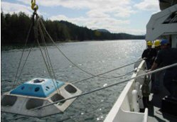
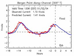
The National Oceanic and Atmospheric Administration (NOAA)/ National Ocean Service's (NOS) Center for Operational Oceanographic Products and Services (CO-OPS) manages the National Current Observation Program (NCOP) to collect, analyze, and distribute observations and predictions of currents. The program's goals are to ensure safe, efficient and environmentally sound maritime commerce, and to support environmental needs such as HAZMAT response. The principal product generated by this program is information used to maintain and update the Tidal Current Tables.
Background
NOAA and its predecessor agencies have collected information on currents in various ports and harbors, and in the Gulf Stream, since the mid-1800's. The Coast and Geodetic Survey first published tidal current predictions for the use by mariners on the East Coast in 1890 and for those on the West Coast in 1898. By 2002, Tidal Current Tables contained predictions for over 2,700 locations throughout the USA.
Most of the data presently in use was collected between 1930 and 1980 when significant resources were dedicated to the program. From the 1960s through the mid-1980s, two NOAA ships (the McARTHUR on the West Coast and Alaska, and the FERREL on the East Coast) and numerous staff oceanographers and technicians were dedicated full-time to the collection, processing, and analysis of tidal current data. These complete comprehensive physical oceanographic surveys measured currents, water levels, water temperatures and salinity, and meteorological data. Many were the first complete physical studies ever conducted on major U.S. estuaries.
Due to budget cuts and ship reassignments in the late 1980s, the program was reduced significantly. Since the mid-1990s, the National Current Observation Program has been recognized as fulfilling a vital mission of national interest to both the maritime industry and environmental stewardship. As a result, many organizations strongly recommend that it is time for the program's data to be updated.
Future Directions
Approximately 70 percent of the stations in the 2001 Tidal Current Tables are over 30 years old. Many of these stations are based on analyses of less than 7 days of data (the data duration is known for 24% of all stations). Channel dredging and changes in the configuration of ports and harbors over the years have significantly altered the physical oceanography of many of the nation's estuaries. Reports from local users indicate that many of NOS's tidal current predictions may be inaccurate. NOS intends to address these deficiencies by rebuilding the program and resampling the currents at every major port and estuary within the next 20 years. The majority of work to deploy, recover, and maintain the program's sensors is likely to be conducted by contractors overseen by NOS staff.


