New coastal forecast system available in Gulf of Maine

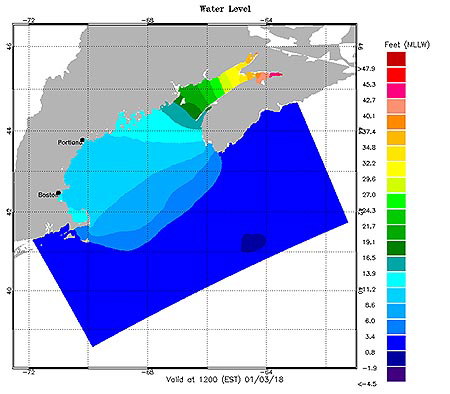
NOAA has unveiled a new coastal conditions forecast system for the Gulf of Maine region, providing users with forecast guidance on water levels, currents, water temperature, and salinity. The model, which forecasts conditions out to 72 hours, promotes safe navigation by helping mariners better plan their transits and prevent accidents.
The information can also be used in other applications for coastal management, ecosystem restoration and protection, harmful algal bloom forecasting, and emergency response.
In addition to the Gulf of Maine, NOAA has coastal and Great Lakes operational forecast systems (OFS) located in the Chesapeake Bay, Delaware Bay, New York/New Jersey harbor, St. John’s River, Tampa Bay, Gulf of Mexico, Great Lakes, Columbia River Estuary, and San Francisco Bay. These systems are implemented in critical ports, harbors, estuaries, Great Lakes and coastal waters of the United States, and form a national backbone of real-time data, tidal predictions, data management and operational modeling.
NOAA’s Center for Operational Oceanographic Products and Services developed the Gulf of Maine OFS along with NOAA’s Office of Coast Survey. It is based on Rutgers University’s Regional Ocean Modeling System and runs on NOAA’s High Performance Computers in a new Coastal Ocean Modeling Framework. As a result, the model has direct access to National Weather Service operational meteorological products, which it needs to run reliably.
For details, please go to Gulf of Maine OFS
More Information
Gulf of Maine Operational Forecast SystemOperational Forecast System
Center for Operational Oceanographic Products and Services (CO-OPS)