National Water Level Observation Network (NWLON)
It seems a very simple task to make correct tidal observations; but in my experience, I have found no observations which require such constant care and attention...
Accurate data about the ever-changing water levels of our nation’s lakes, estuaries, and oceans provides the foundation for many coastal activities. From navigation to engineering to preservation, water levels are one of the most critical pieces of oceanographic data used to protect life, property, and the environment. The National Oceanic and Atmospheric Administration’s (NOAA) Center for Operational Oceanographic Products and Services’ (CO-OPS) manages a permanent observing system, the National Water Level Observation Network (NWLON). The NWLON is the foundation of the comprehensive system for observing, communicating, and assessing the impact of changing water levels nationwide. NWLON data-collection platforms also measure other oceanographic parameters in addition to water levels, including meteorological parameters.
With a network of 210 long-term, continuously operating water level stations throughout the US and its territories, the NWLON is the “go to” source for government and commercial sector navigation, recreation, and coastal ecosystem management. Approximately one quarter of the NWLON is located in the Great Lakes (non-tidal), providing water level data for the international management of those water resources. The NWLON provides the national standards for tide and water level reference datums used for nautical charting, coastal engineering, International treaty regulation, and boundary determination. The NWLON is also widely recognized as the key federal component of the Integrated Ocean Observing System (IOOS). CO-OPS also installs and operates approximately 100 short-term water level stations annually in support of a variety of programs including hydrographic and shoreline mapping projects, marine boundary determination, real time navigation systems, coastal habitat and marsh restoration projects, and NOS VDatum projects.
Since the first water level observing stations were established in the 1850s, the network of observing stations, analysis techniques, and product integration have evolved to support both national and local needs. Originally established to support safe navigation through tide predictions and nautical charts, the observing stations now contribute to NOAA’s forecast models which provide tsunami and storm surge warnings. With technological innovations in data collection and communication, real-time water level information is now available 24/7 to everyone from commercial navigators and recreational boaters needing information to avoid groundings, to coastal planners whose marsh restoration efforts must account for changing water levels and the destructive potential of hurricane storm tides.
For National Water Level Program information, contact:
National Water Level Program
Center for Operational Oceanographic Products and Services (CO-OPS)
1305 East-West Highway
Silver Spring, MD 20910-3281
Phone: (301) 713-2815
Fax: (301) 713-4500
E-mail: National Water Level Program (co-ops.userservices@noaa.gov)
-
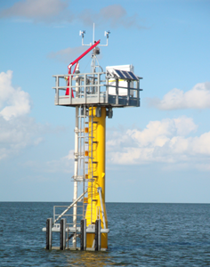
NWLON Sentinel Station
Some NWLON stations are specially reinforced to withstand hurricanes and other major storm events. The reinforced stations are better able to keep functioning during these events, providing critical information on water levels and winds that aids emergency response organizations.
-
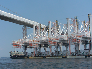
Ship Transit
A shipment of cranes going under a bridge. NWLON sensors make such shipments possible by providing real-time water level observations, allowing ship captains to determine when it is safest to transit.