PORTS® (Physical Oceanographic Real-Time System)
The National Ocean Service (NOS) is responsible for providing real-time oceanographic data and other navigation products to promote safe and efficient navigation within U.S. waters. The need for these products is great and rapidly increasing; maritime commerce has tripled in the last 50 years and continues to grow. Ships are getting larger, drawing more water and pushing channel depth limits to derive benefits from every last inch of draft. By volume, more than 95 percent of U.S. international trade moves through the nation's ports and harbors, with about 50 percent of these goods being hazardous materials. A major challenge facing the nation is to improve the economic efficiency and competitiveness of U.S. maritime commerce, while reducing risks to life, property, and the coastal environment. With increased marine commerce comes increased risks to the coastal environment, making marine navigation safety a serious national concern. From 1996 through 2000, for example, commercial vessels in the United States were involved in nearly 12,000 collisions, allisions, and groundings.
PORTS®
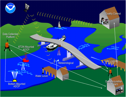
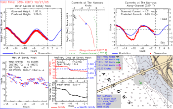
PORTS® is a decision support tool that improves the safety and efficiency of maritime commerce and coastal resource management through the integration of real-time environmental observations, forecasts and other geospatial information. PORTS® measures and disseminates observations and predictions of water levels, currents, salinity, and meteorological parameters (e.g., winds, atmospheric pressure, air and water temperatures) that mariners need to navigate safely.
Program Objectives
The objectives of the PORTS® program are to promote navigation safety, improve the efficiency of U.S. ports and harbors, and ensure the protection of coastal marine resources.
Navigation Safety: The real-time tide and current data provided through PORTS® represents one component of NOS's integrated program to promote safe navigation. PORTS® data, when combined with up-to-date nautical charts and precise positioning information, can provide the mariner with a clearer picture of the potential dangers that may threaten navigation safety. NOS fulfills its navigation safety mission in close concert with other federal agencies, such as the U.S. Coast Guard and the U.S. Army Corps of Engineers.
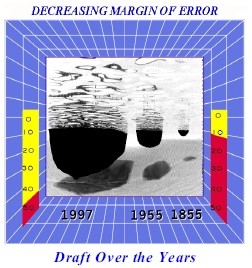
Improved Economic Efficiency: Our nation's waterfronts, ports and harbors have historically been centers of rapid industrial and urban growth, and have advanced critical national objectives by promoting energy exploration, fishery production, commerce, and recreation. In 2002 alone, commercial port activities provided employment for 1.1 million Americans and $44 billion in personal income, and generated approximately $16 billion in federal, state and local taxes. Increasingly, shipping companies are implementing new navigation systems aboard ships to maximize cargo load while reducing uncertainties in under keel clearances. These new systems rely on the availability of real-time tide/current and other information. One additional foot of draft may account for between $36,000 and $288,000 of increased profit per transit. Knowledge of the currents, water levels, winds, and density of the water can increase the amount of cargo moved through a port and harbor by enabling mariners to safely utilize every inch of dredged channel depth.
Coastal Resource Protection: Most ports are located at the mouths of major estuaries, which provide critical habitat for many important biological resources. For example, coastal waters provide nurseries and spawning grounds for 70 percent of U.S. commercial and recreational fisheries. Commercial fishing employs over 350,000 people in vessel- and shore-related fisheries work. An additional 17 million people participate in recreational saltwater fishing, spending $7.2 billion annually. Activities at ports can greatly affect these critical resources; dredging is but one such activity. Each year in the U.S., approximately 400 million cubic yards of dredged material are removed from navigation channels, berths, and terminals.
The prevention of maritime accidents is the most cost-effective measure that can be taken to protect fragile coastal ecosystems. In 2004 alone, NOS's Office of Response and Restoration responded to over 120 events, including the release of 270,000 gallons of crude oil into the Delaware River near Philadelphia, and spill of over 400,000 gallons of bunker oil in Alaska. One major oil spill (e.g., the 1989 Exxon VALDEZ accident) can cost billions of dollars and destroy sensitive marine habitats critical to coastal ecosystems. PORTS® provides information to make navigation safer, thus reducing the likelihood of a maritime accident, and also provides information to mitigate the damages from a spill, should one occur.
PORTS® provides accurate real-time oceanographic information, tailored to the specific needs of the local community. PORTS® systems come in a variety of sizes and configurations, each specifically designed to meet local user requirements. The largest of NOS's existing PORTS® installations is comprised of over 50 separate instruments; the smallest consists of a single water-level gauge and associated meteorological instruments (e.g., winds, barometric pressure, etc.). Regardless of its size, each PORTS® installation provides information that allows mariners to maintain an adequate margin of safety for the increasingly large vessels visiting U.S. ports, while allowing port operators to maximize port throughput.
PORTS® has the potential to save the maritime insurance industry from multi-million dollar claims resulting from shipping accidents. PORTS® is accessible to maritime users in a variety of user-friendly formats, including telephone voice response and Internet. PORTS® also provides forecasts via numerical circulation models. Telephone voice access to accurate real-time water-level information allows U.S. port authorities and maritime shippers to make sound decisions regarding loading of tonnage (based on available bottom clearance), maximizing loads, and limiting passage times without compromising safety.
PUFFF (PORTS Uniform Flat File Format) Specification (PDF)