Help Page for Physical Oceanographic Real-Time System (PORTS)
The Physical Oceanographic Real-Time System (PORTS) page provides access to oceanographic and meteorological observations and predictions for the station indicated in the upper left corner of the page. For each station, some or all of the following data may be offered: water levels, currents, salinity, wind, atmospheric pressure, visibility, and air gap. Some of the links on the page may lead to data for several nearby stations within the PORTS network. The data is real-time, updated frequently from the most recent measurments.
Click on any of the images to see plots or maps of the data type indicated. Click the link below the images to view the text-based PORTS screen. Click "Go to PORTS Page" for more information about PORTS and access to all PORTS networks. Link to other types of data for the same station using the links on the left. Links are highlighted only for data types that are available for the station.
Each PORTS station has one or more of the following links to real-time observations and predictions. More information about each page is available through the Page Help link that appears on the page itself.
Composite
All Water Level
All Current
All Met
All CT
3 Days WL/Met
3 Days Current
3 Days Air Gap
3 Days CT
Air Gap
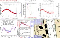
- Composite - Overview page that includes a limited view of several types of data available for the station.
- All Water Level - Plots of recent water levels and predicted water levels at nearby PORTS stations.
- All Current - Plots of recent observed and predicted water currents at nearby PORTS stations.
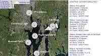
- All Met - Map showing wind direction and speed at nearby stations, with data also provided as text.
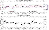
- All CT - Plots of recent conductivity at nearby PORTS stations.
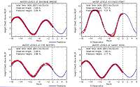
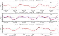
- 3 Days Current - Plots of water currents at several depths for the last three days at the station.
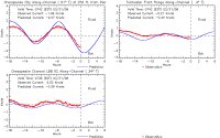
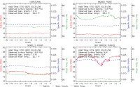
- 3 Days WL/Met - Plots of water level, wind, barometric pressure, air and water temperature for the last three days at the station.
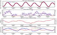
- 3 Days Air Gap - Plots of air gap, water level, and wind for the last three days at the station.
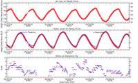
- 3 Days CT - Plots of conductivity for the last three days at the station.
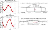
- Air Gap - Plot of recent air gap (vertical distance between a bridge and the surface of the water) observations.