Notification Of Updated Tidal Datums
USING THE 2012-2016 MODIFIED PROCEDURE FOR COMPUTING ACCEPTED TIDAL DATUMS
For Areas With Anomalous Sea Level Trends
USING THE 2012-2016 MODIFIED PROCEDURE FOR COMPUTING ACCEPTED TIDAL DATUMS
For Areas With Anomalous Sea Level Trends
SUMMARY: NOAA's National Ocean Service (NOS), Center for Operational Oceanographic Products and Services (CO-OPS), last updated the Nation's tidal datums to a new National Tidal Datum Epoch (NTDE) in April 2003 to adjust for changes in mean sea level that have occurred along the Nation's coast over the past 25 years. The NTDE was updated from the 1960-1978 to the 1983- 2001 time period effective on May 28, 2003 (Federal Register, volume 68, Number 102). The NTDE is a specific 19-year period over which tide observations are taken to determine Mean Sea Level and other tidal datums such as Mean Lower Low Water and Mean High Water. This period includes an 18.6 year astronomical cycle that accounts for all significant variations in the distances to the moon and sun that cause slowly varying changes in the range of tide. It is the policy of NOS to consider a revised NTDE every 20-25 years in order to take into account relative sea level changes caused by global sea level rise and the effects of long term land movement on local sea level due to subsidence or glacial rebound. The NTDE of 1983-2001 has been adopted so that all tidal datums throughout the United States will be based on one specific common reference period.
In 1998, NOS recognized the need for a modified procedure for computing accepted tidal datums for regions with anomalously high rates of relative sea level change, and has adopted a 5 year computational period to better reflect the current mean sea level datum. Consequently, tidal datums at stations exhibiting anomalous trends are computed from MSL observations for the most recent 5 year time period, and tidal ranges based on the most recent 19 year NTDE observations at that station. Anomalous relative sea level trends are seen along the western Gulf Coast, southeast Alaska, and southern Cook Inlet, AK (Figure 1). The magnitudes of the sea level trends in these areas are so large, (+9.09 mm/yr in Grand Isle, LA; -13.14 mm/yr in Juneau, AK; and -9.91 mm/yr in Seldovia, AK), that computation of a 19-year epoch value for mean sea level has little practical meaning.
The modified procedure is necessary at selected stations to ensure that the tidal datums accurately represent the existing stand of sea level. Sea level analyses in these anomalous regions are conducted approximately every five years to determine if the sea level trend exceeds the established 9.0mm/yr threshold tolerance in order to qualify for a 5-yr modified procedure datum update. A detailed report explaining this modified procedure can be found in the publications section of the CO-OPS Tides & Currents website at http://tidesandcurrents.noaa.gov/pub.html.
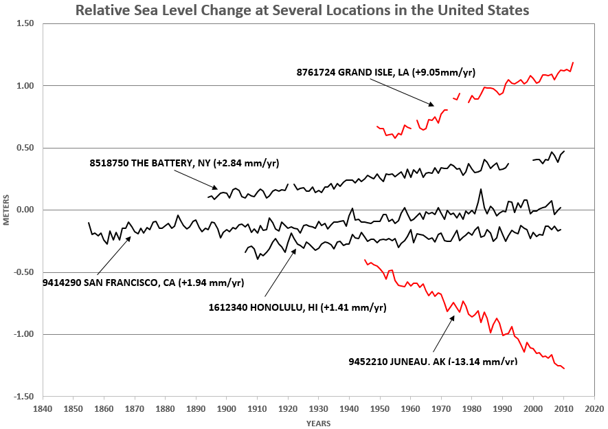
Figure 1: Plots of relative sea level change for several locations around the U.S. highlights the anomalous trends in Louisiana and Alaska.
The current modified procedure datum update for 2012-2016, will affect the following NOAA national Water Level Observation Network Stations:
Control Stations
8761724 Grand Isle, LA
9452210 Juneau, AK
9452400 Skagway, AK
9455500 Seldovia, AK
9457292 Kodiak, AK
9453220 Yakutat, AK
Subordinates
8760417 Devon Energy Facility, LA
8760551 South Pass, LA
8760721 Pilottown, LA
8760781 Shell Oil, LA
8760889 Olga Compressor Sta., LA
8760922 Pilots Station East, LA
8760943 Pilots Station, LA
8761198 Chevron Station 289, LA
8761414 Billet Bay Community, LA
8761484 Lease VB #4, LA
8761602 Lake Judge Perez, LA
8761679 St. Marys Point, LA
8761742 Mendicant Island, LA
8761799 M.V. Petroleum Dock, LA
8761819 Texaco Dock, LA
8761826 Cheniere Caminada, LA
8761899 Lafitte, LA
8761962 Texaco Gas Expl. Dock, LA
8762075 Port Fourchon, LA
8762084 Leeville, LA
8762184 Golden Meadow, LA
8762223 East Timbalier Island, LA
8762231 Salvador WMA, LA
8762372 East Bank 1, LA
8762482 West Bank 1, LA
8762888 E. Isle Dernieres, LA
8762928 Cocodrie, LA
9452067 Holkham Bay, AK
9452123 Taku Harbor, AK
9452249 Young Bay, AK
9452294 Hawk Inlet Entrance, AK
9452318 Barlow Cove, AK
9452346 Cove Point, AK
9452368 Swanson Harbor, AK
9452421 Chilkat Inlet, AK
9452434 Taiyasanka Harbor, AK
9452437 Excursion Inlet (S End), AK
9452438 Hoonah, AK
9452749 Tarr Inlet, AK
9453443 Moraine Bay, AK
9455437 Port Grahan, AK
9455517 Kasitsna Bay, AK
9455595 Bear Cove, AK
9455606 Anchor Point, AK
9455653 Ninilchik, AK
9455760 Nikiski, AK
9457287 Ouzinkie, AK
9457391 Port Lions, AK
9457512 Sitkalidak Isl. GPS Tide Buoy, AK
9457527 Old Harbor, AK
9457634 Japanese Bay, AK
9457726 Geese Isl. GPS Tide Buoy, AK
9458293 Cherikof Island, AK
Due to the small vertical changes which result from these modified procedure datum updates (~0.03m (~0.10 foot) to ~0.16m (0.5 foot)), the overall accuracy of hydrographic-cartographic processes at the scale of the NOAA nautical charts, the shoreline, depth soundings values, isobaths, etc., are not significantly modified as a result. However, in regions that have experienced rapid land movement, changes to actual soundings and shoreline depiction may be required on the next regularly scheduled chart edition. Although depictions of the datum changes will not be evident on the largest scale NOS nautical charts, the datum changes will be noticeable when establishing or re-occupying tide stations using accepted surveying techniques and the numerical relationships for tidal benchmarks provided by NOS' CO-OPS. These tidal datum relationships are made available to the public in the form of accepted tidal datums and published tidal benchmark sheets available at http://www.tidesandcurrents.noaa.gov/. This action is necessary to provide the latest up-to-date information available for applications that are essential to supporting Federal, State and private sector coastal zone activities, including hydrographic surveys and coastal mapping, navigational safety, wetland restoration, marine boundary determinations, coastal engineering, storm warnings and hazard mitigation, emergency management, and hydrodynamic modeling. There are generally no changes required to the NOAA tidal prediction products put out by NOAA as a result of these updates. Users will note that predicted and observed elevations will generally agree more closely during normal weather conditions after the update than previous predicted tides versus observed water levels.