NOAA CO-OPS Water Level Stations
TULALIP, WASHINGTON
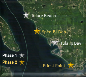
Tulare Beach * Tulalip Bay * Spee-Bi-Dah * Priest Point
TULALIP, WASHINGTON
Tulare Beach * Tulalip Bay * Spee-Bi-Dah * Priest Point
Introduction
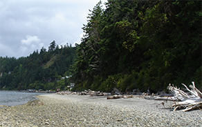
NOAA's Center for Operational Oceanographic Products and Services (CO-OPS) installed four temporary water level stations along the Washington coast from Tulare Beach to Priest Point. The water level data collected from these stations were used for a variety of purposes to include updating historic tidal datum elevations, to support safe navigation, marine boundary delineation, habitat restoration, coastal planning and management, engineering, and coastal hazard mitigation.
Outreach and Feedback
A Shoreline Tidal Boundary Community meeting was held in Tulalip, WA on April 25, 2013. During the meeting, concerns were expressed about keeping the community informed of the project's progress and how many community members were unable to attend the meeting. In order to keep the community informed, an outreach plan was created to address these concerns.
Project Specifics:
- The water level stations were installed in two phases spanning two years
- Phase 1: Tulare Beach, WA and Tulalip Bay, WA (May and July 2013)
- Phase 2: Spee-Bi-Dah, WA and Priest Point, WA (June 2014)
- Each station collected at least 3 months of water level observations
- After each station removal, verified water level data, tidal datums, benchmark sheets, and tide predictions for Phase 1 and 2 became available on tideandcurrents.noaa.gov
- This website has been updated at the end of each phase with links to water level products created
Background
CO-OPS is the authoritative source for accurate, reliable, and timely tides, water levels, currents and other oceanographic information. Our data, products and services support safe and efficient navigation, sound ecosystem stewardship, coastal hazards preparedness and response, and the understanding of climate change. The historical tidal datum information for the Tulalip area was 50-80 years old. Due to changes in sea level rise and shoreline configuration over the years, the shoreline has evolved and new water level observations provided us with the ability to update the tidal elevations. Tidal datums were calculated which can be used to determine shoreline boundaries. These elevations are tied to brass benchmarks permanently installed in the vicinity where each station was installed. As long as these benchmarks are left undisturbed, surveyors will be able to measure the elevation of any nearby piece of land in relation to the tidal datums. An additional benefit will be that accurate tide predictions were computed for each station.
Project Report
The purpose of the NOAA Technical Report NOS CO-OPS 081 - Shoreline Tidal Boundary Project For Tulalip, WA is to document the CO-OPS support of the Tulalip Tribes in establishing marine boundaries. The report documents the field work required for station installation, data collection and processing, tidal datum computation, and tidal bench mark elevation determination required to meet the needs of the Tulalip Tribes.