St. Charles Parish Real-Time Monitoring System
-
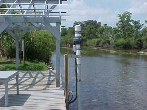
St. Charles Tide Gauge
The St. Charles Parish Water Level Monitoring System was established through a partnership between the NOAA/NOS/Center for Operational Oceanographic Products and Services (CO-OPS) and St. Charles Parish, Louisiana. This real-time water-level monitoring system will provide critical information to save lives, protect property, and restore the environment in this community.
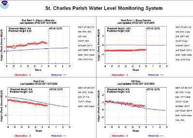
A dedication ceremony was held on June 4, 2003, to celebrate the official operation of the St. Charles Parish Water Level Monitoring System. The system consists of two real-time tide and water-level stations -- one in Lake Pontchartrain in Norco at Bayou LaBranche, and one in Lake Salvador at Bayou Gauche -- plus two existing National Water Level Observation Network (NWLON) stations at Grand Isle and SW Pass.
The two new stations will supplement the NWLON, which is the foundation for the National Water Level Program (NWLP) operated and maintained by NOAA/NOS/CO-OPS.
The data from all four water-level stations, including meteorological data, are displayed on a local data acquisition system in the Parish Emergency Operations Center located in the Hahnville Courthouse. Emergency managers can monitor the data to assess storm-surge flooding and to make decisions regarding evacuation routes in the event of a flood. Residents of St. Charles Parish and neighboring parishes can access the data in real-time via this website or by telephone (1-866-557-6787). The data are also fed directly into NOAA's National Weather Service to improve storm-surge and hurricane modeling efforts. The data will also be beneficial for assessments of sea-level rise and coastal restoration. The Norco, Bayou LaBranche station will improve modeling efforts for the restoration of the LaBranche Wetlands.